- Topic
- Safety and urban mobility
- Country
- Sweden
- Resource type
- Case study
First published on 12 October 2020.
Geofencing applications are starting to appear on city streets, with the electric mode of hybrid vehicles being turned on in specific city areas or for enforcing speed limits (e.g. in the vicinity of schools and city centres). Sweden, and particularly the city of Gothenburg, are leading the way in this area by testing geofencing in a bid to make urban transport safer and more sustainable. The first available results are encouraging, highlighting geofencing’s potential to enable safer and more environmentally friendly urban mobility.
Context
As with other European cities, Gothenburg wants to mitigate the effects of climate change by promoting sustainable urban mobility. Furthermore, poor air quality leads to around 300 premature deaths in the city each year and noise exposure has an estimated economic cost of EUR 96 million.
Gothenburg is adopting a hands-on approach to become more space-efficient, silent, clean and safe. It is determined to deploy a climate sound strategy aiming to reach a sustainable and equitable level of greenhouse gas emissions by reducing them from the current 8 tonnes CO2e/year per inhabitant to less than 2 tonnes CO2e/year per inhabitant in 2050.
Following the 2017 terrorist attack in Drottninggatan in Stockholm, the Government commissioned the Swedish Transport Administration, together with local government and industrial partners in Gothenburg and Stockholm, to test geofencing in urban environments as part of a demonstration project. In addition, the project aimed to promote legislation and regulations that support the implementation of geofencing, develop organisational and digital processes and data for geofencing zones, and promote national and international harmonisation.
In action
Geofencing uses a virtual perimeter for an actual geographic area inside which digital traffic regulations can be applied. This enables instant sharing of regulations with vehicles that are connected to cloud services or use cooperative intelligent transport systems Wi-Fi (C-ITS G5). In addition, this gives vehicle manufacturers and/or the vehicle owners an opportunity to let the vehicle respond autonomously to the digital regulations. The benefits of this technique are widespread, with great potential for urban mobility planning, namely by restricting access to certain zones.
By enabling geographical areas to be defined and attaching rules to these zones, geofencing ensures that hybrid vehicles use the right powertrain at the correct time and in the appropriate place, as well as keeping the vehicle to the preferred speed in certain settings. By applying this technique, cities can create green zones, allow for better traffic flows, lower traffic noise and air pollution, and make public spaces safer to use.
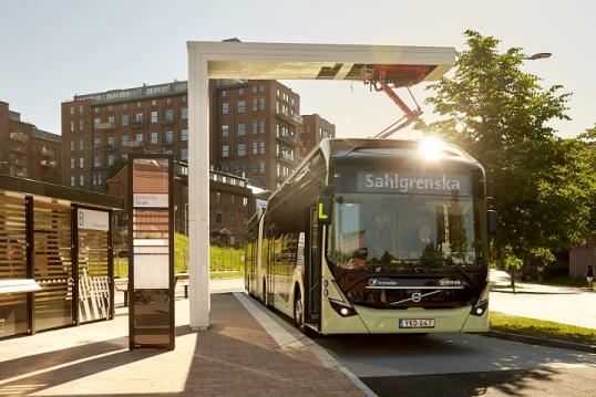
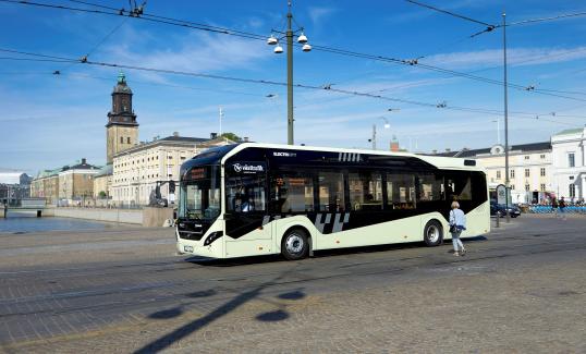
These are the objectives of a project concerning bus routes 55 and 16 in Gothenburg. Route 55 is an electric bus route that came into service within the scope of the ElectriCity project. This project brought together business, academia and the public sector to promote sustainable public transportation services. For the past 5 years, the city has used geofencing techniques on 10 vehicles, with very encouraging results.
The buses operating on routes 55 and 16 are either electric or hybrid vehicles. Geofencing is being used on both routes, limiting the speed of the vehicles and forcing hybrid vehicles to automatically switch to the electric engine on certain digitally limited stretches of the routes (i.e. zones with many pedestrians and cyclists). This enables the City to set digital traffic regulations at the most appropriate speed to be used in specific areas, as well as ensuring less air pollution and quieter public transport in designated areas.
Data is an essential element for the operationalisation of the technique and for future transport management. The data that is used by the buses for geofencing is programmed into the vehicles. In the future, the aim is for the data to be stored elsewhere and downloaded into the vehicles as they enter a specific area.
Results
The results, particularly on the reliability of the system, are encouraging. Bus drivers feel that the system in place assists them in focusing solely on the driving aspect, thus reducing the risk of accidents. The system is also reliable to the extent that the speed limits that have been enforced have not been exceeded and emissions have decreased. In addition, fleet owners report that vehicles have been damaged less.
One of the most unexpected outcomes is that nearly all stakeholders involved (drivers, fleet owners and vehicle manufacturer) are happy to have their operations controlled by geofencing.
In 2018, to make the geofencing technique even smarter, Gothenburg tested providing different vehicle producers with digitised IRL (in real life) zone information. This was done by investigating in what format, and by which channels, the information needed to be provided for vehicles to use. The results data was collected real time, which led to interesting findings and revealed that the technique is reliable.
There are several associated benefits to this technique, such as:
- better use of shared spaces;
- decreased emissions and better air quality;
- improved road safety;
- control over traffic flows;
- the potential to contribute to climate targets.
Geofencing enables a vehicle to adapt to the city environment based on its position, which is identified using a Global Positioning System (GPS). This means that, for instance, the vehicle’s speed or drive mode can be limited and/or adjusted to different times of the day. The technique is also versatile enough to be deployed on motorways, major arterial roads, densely populated areas and in city centres.
Malin Stoldt, ITS Project Manager at the City of Gothenburg said, ‘The tests made in collaboration with business and academia showed encouraging results, highlighting geofencing’s potential for safer and more environmentally friendly urban mobility.’
The geofencing scheme positively affects around 100,000 people (those living in the city centre), representing around 15-20% of Gothenburg’s total population. According to figures from 2019, the share of public transport in Gothenburg is 30%, up from 25% in 2011. The target set for 2035 is 36%. According to the latest report on air pollution (2019), oxides of nitrogen (NOx) and particulate matter levels in the city centre are decreasing. However, they are still above the environmental quality standards that city representatives expect and are not yet sufficient to enable the city to reach its climate targets.
Challenges, opportunities and transferability
Gothenburg’s case focuses on creating the right conditions for geofencing, bearing in mind that introducing this on a larger scale is complex and not without challenges. The project, which was commissioned by the Swedish Government, also developed a pilot in Stockholm, with a slightly different focus. There, the geofencing technology has been tested using distribution trucks that automatically switch to their electric mode when entering emission-sensitive areas. The transferability dimension is at the core of the project with the clear intention of expanding the technique throughout the country.
The goal is that, by 2022, the Swedish Government will have developed procedures enabling cities to implement geofencing in the cities, while providing incentives for connected vehicles and infrastructure. This could be done by creating increased access to certain city areas in the rush hour or during the evening. The ambition is also for geofencing to be used in an entire city zone, with rules set by the corresponding managing authorities, in line with the expectations of residents. This would result in the creation of dynamic smart zones with rules and requirements, for which vehicle adaptation would be needed.
One of the main lessons learned is that, for the successful implementation of geofencing, there is a pressing need for full collaboration between all stakeholders (public transport entities, fleet owners and technology providers). Otherwise, the potential for creating attractive and tailor-made solutions is curtailed. An additional conclusion is the importance of making city data available for all stakeholders involved.
Furthermore, the potential for connected vehicles to improve safety on roads is substantial, since the communication between them will allow, for instance, a bus to inform another bus about a slippery road in the vicinity. Connected vehicles also allow for real-time driver coaching to ensure that fuel and energy-efficient driving is fully exploited.
The results and associated system reliability suggest that geofencing could enable cities and public transport authorities to control their fleets in dimensions such as powertrain, speed and access to specific areas of the cities. There are two main challenges to be addressed to achieve the widespread deployment of large-scale geofencing – the need for a functioning digital infrastructure and an appropriate regulatory framework.
Technology is not the main issue, but rather standardisation and information sharing are important. There is also a need for further maturation to address the sensitivity of geofencing to external influences and interference, which might affect its reliability. Therefore, additional research and development activities need to be carried out to create a complete system so enabling geofencing to be implemented in larger, predefined urban zones.
There is also a mismatch between regulation and technology development since the latter is developing faster. On a regulatory level, the challenge is to develop solutions that can be easily transferred at an international level by establishing a national digital infrastructure that is in line with European standards, which will avoid each country creating its own standards. In addition, there is a need to harmonise data exchange methods and message types, but there is still a long way to go in this area.
Some interesting EU-funded initiatives are being carried out to address these issues (e.g. the pilot NordicWay projects). These aim to enable vehicles, infrastructure and network operators to communicate safety hazards and other road information between different stakeholders.
Other challenges that affect the success of this technology are:
- the mix of new and old vehicles on the road;
- the mix of voluntary and mandatory services, and the level of penetration of these depending on the categories;
- the need for up-to-date information and high-quality data;
- the accuracy of GPS and the need for storage (to handle all of the information);
- the acceptance by users and the public, negative perceptions and emotional aspects of the desire to control (particularly for private car drivers);
- changes in institutional arrangements within and between road operators.
All in all, geofencing is a new tool with substantial potential for forward-looking cities to increase safety in urban areas and reduce the environmental impact of public transport. Urban mobility challenges are evolving, but so is the toolbox that local authorities can count on to solve them.
In Depth
More information about geofencing in Gothenburg (in Swedish) can be found here.
More information on the ElectriCity project (in English) can be found here.
More information about the NordicWay projects can be found here.
For more specific relevant information please contact:
- Mikael Ivari, Senior Advisor at Urban Transport Administration, City of Gothenburg e-mail: Mikael [dot] Ivari
 trafikkontoret [dot] goteborg [dot] se (Mikael[dot]Ivari[at]trafikkontoret[dot]goteborg[dot]se)
 - Malin Stoldt, ITS Project Manager at Urban Transport Administration, City of Gothenburg e-mail: Malin [dot] Stoldttrafikkontoret [dot] goteborg [dot] se (Malin[dot]Stoldt[at]trafikkontoret[dot]goteborg[dot]se)